Using lidar technology from the sky, researchers have uncovered vast Maya megalopolises hidden beneath dense jungle canopies. This laser mapping reveals detailed images of ancient cities, including structures, roads, and water systems, that were previously inaccessible. It shows us the impressive scale and complexity of Maya urban planning and infrastructure. If you’re curious, you’ll discover how this groundbreaking tech transforms our understanding of the Maya civilization’s size and sophistication.
Key Takeaways
- Lidar technology uncovers detailed 3D maps of Maya cityscapes hidden beneath dense jungle canopies.
- It reveals extensive urban infrastructure, including pyramids, plazas, causeways, and reservoirs.
- Lidar shows sprawling interconnected city networks spanning hundreds of square kilometers.
- It provides evidence of advanced Maya land and water management systems.
- The mapping transforms understanding of Maya civilization’s scale, complexity, and urban planning.
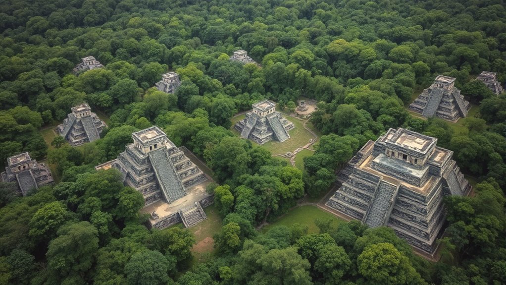
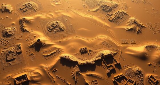
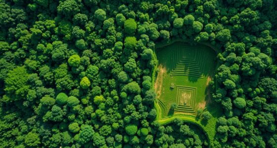
Thanks to advanced lidar technology, researchers have now mapped sprawling Maya megacities from the sky with unprecedented detail. This groundbreaking development allows you to see the scale and complexity of these ancient urban centers, revealing features hidden beneath dense jungle canopies. Lidar technology uses laser pulses to penetrate vegetation and produce highly accurate 3D maps of the ground beneath. With this tool, you can now explore the intricate layout of Maya cityscapes, uncovering structures, causeways, and reservoirs that were once concealed from view. The clarity provided by lidar enables you to appreciate the sophistication of Maya urban planning, which was far more advanced than previously believed.
Before lidar, much of what you knew about Maya cities came from surface archaeology, which often left large parts of these sites obscured or incomplete. Now, you can see how Maya architects carefully designed their cities with an eye toward functionality, aesthetics, and social organization. Large plazas, pyramids, and ball courts are mapped precisely, giving you insight into how the Maya coordinated their urban spaces for religious, political, and social purposes. The technology reveals the extent of the urban sprawl, showing not just individual monuments but also the network of roads and agricultural terraces that sustained these populations. As you analyze the data, you’ll notice that Maya cities were planned with strategic placement, connecting neighborhoods and resource zones in ways that fostered cooperation and efficient resource management.
The use of lidar technology also changes your understanding of the scale of Maya civilization. Instead of isolated temples or ceremonial centers, you see a vast, interconnected system of urban areas spanning hundreds of square kilometers. This challenges old assumptions that Maya cities were small or limited in scope. Now, you understand that the ancient Maya built sprawling megacities, with complex infrastructure supporting large populations. The detailed mapping exposes how these urban centers were carefully organized to accommodate social hierarchies and facilitate communication across different regions. You observe evidence of planned water management systems and terraced farming—testament to the Maya’s advanced knowledge of landscape manipulation and urban design. The integration of urban planning and landscape engineering demonstrates their sophisticated understanding of environmental adaptation and resource management.

BORNFFINALLY Livox Avia High-Performance LiDAR Sensor Lase Radar 3D Mapping & Robotics Navigation Drone Surveying,Applicable to Electric Power, Forestry, Smart City Self-Driving Robots Drones
🚀 Extended Detection & Triple-Return TechnologyAchieves a maximum detection range of 450 meters in low-light conditions (cloudy days,…
As an affiliate, we earn on qualifying purchases.
As an affiliate, we earn on qualifying purchases.
Frequently Asked Questions
How Does Lidar Technology Differentiate Between Natural and Man-Made Structures?
When using lidar, you can differentiate between natural and man-made structures by analyzing their structural signatures. Vegetation removal helps expose these signatures, making buildings stand out clearly. Man-made structures often have sharp, straight edges and regular shapes, while natural features are more irregular. By examining these differences, you can identify and map various features accurately, even under dense vegetation, revealing the hidden details of the landscape.
What Challenges Do Researchers Face When Interpreting Lidar Data in Dense Forests?
Interpreting lidar data in dense forests feels like trying to untangle a million invisible strings in a swirling storm. You struggle with the dense canopy, which often obscures the ground, making it seem like an endless sea of leaves. Data distortion from overlapping signals complicates mapping, forcing you to work tirelessly to distinguish natural features from artifacts. It’s a relentless challenge that demands patience, precision, and innovative techniques.
Can Lidar Detect Underground Structures Beneath the Maya Cities?
You might wonder if lidar can detect underground structures through dense forest cover. While lidar excels at surface mapping, its ability for subsurface detection is limited. It primarily provides detailed surface and near-surface data, making underground mapping challenging. To identify underground structures beneath Maya cities, researchers often combine lidar with other geophysical techniques like ground-penetrating radar, which better penetrates soil and reveals subsurface features.
How Has Lidar Changed Our Understanding of Maya Social and Political Organization?
You see, lidar has revolutionized how you understand Maya social and political organization. It reveals vast urban planning networks and extensive ceremonial centers that were previously hidden. This technology shows how cities were interconnected, with clearly defined social hierarchies. You can now appreciate the complexity of their political systems and communal spaces, transforming your view of Maya civilization from isolated city-states to an intricate, organized society built around shared religious and political centers.
Are There Plans to Use Lidar to Discover New Maya Sites in Unexcavated Regions?
You’re probably wondering if lidar exploration will uncover hidden Maya secrets in unexcavated sites. The good news is, scientists are actively planning and using lidar technology to scan vast, untouched regions, revealing lost cities and structures that were once invisible. This cutting-edge method might just rewrite history again, revealing mysteries buried deep beneath the jungle canopy. So, yes—more astonishing discoveries are undoubtedly on the horizon!

Revopoint MetroX Pro 3D Scanner for 3D Printing, Industrial-Grade Precision 0.01mm, 30+15 Blue Laser Scan, Full Color Scanning, for Reverse Engineering & Automotive Modeling, Advanced
Industrial-grade High-precision Scanning: Flawlessly capture every detail and dimension with MetroX Pro's industrial-grade blue laser scanning. It offers…
As an affiliate, we earn on qualifying purchases.
As an affiliate, we earn on qualifying purchases.
Conclusion
As you look at these lidar maps, you can imagine uncovering hidden Maya cities like a detective solving a mystery. Just as a flashlight reveals secrets in the dark, lidar from the sky uncovers ancient structures buried beneath the jungle. This discovery is a breathtaking journey into the past, showing that the Maya’s civilization was as vast and intricate as a spider’s web. You’re witnessing history come alive, piece by hidden piece.

Digging With Light: How Technology is Reimagining the Archaeological Past (Academic Studies in Archaeology)
As an affiliate, we earn on qualifying purchases.
As an affiliate, we earn on qualifying purchases.

Laser Beam Scanning: Opto-Mechanical Devices, Systems, and Data Storage Optics (Optical Science and Engineering)
As an affiliate, we earn on qualifying purchases.
As an affiliate, we earn on qualifying purchases.