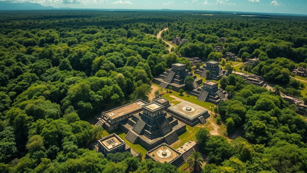

Using lidar technology from aircraft, scientists have uncovered vast, interconnected Maya urban networks hidden beneath dense jungle canopies. You can now see detailed 3D maps showing buried platforms, walls, roads, and agricultural features that were invisible before. This breakthrough reveals huge cities with sophisticated planning, water systems, and marketplaces, challenging previous ideas about their size and complexity. If you keep exploring, you’ll discover how these discoveries transform our understanding of Maya society and urban development.
Key Takeaways
- Lidar technology reveals extensive, interconnected Maya urban networks hidden beneath jungle canopies.
- Reveals causeways, reservoirs, and agricultural terraces linking Maya city centers.
- Transforms understanding of Maya society from isolated ruins to complex, organized urban civilizations.
- Demonstrates sophisticated Maya urban planning, including water management and environmental engineering.
- AI analysis of lidar data uncovers previously unknown structures, expanding knowledge of Maya civilization’s scale.

Thanks to advances in lidar technology, researchers have now revealed the true extent of Maya megalopolises, uncovering vast urban networks hidden beneath dense jungle canopies. Before this breakthrough, much of what we knew about these ancient city complexes was limited to surface excavations and ground surveys, which often missed the full scale of the Maya civilization’s reach. Now, with aerial imaging powered by lidar, you can see through the thick foliage to unveil sprawling cityscapes that stretch across hundreds of square kilometers. This technology sends laser pulses from aircraft, bouncing off the ground and returning data that creates detailed 3D maps. As you examine these maps, what once appeared as isolated ruins now reveal themselves as interconnected hubs, with causeways, reservoirs, and agricultural terraces forming a complex urban fabric.
Lidar reveals vast, interconnected Maya cities hidden beneath dense jungle canopy.
Lidar imaging dramatically shifts your understanding of the ancient city. Instead of isolated temples or pyramids, you see a network of interconnected communities, administrative centers, and marketplaces that support a thriving civilization. The detailed aerial imaging exposes features that are invisible to the naked eye, such as buried platforms, walls, and roadways, allowing you to piece together the city’s layout without invasive digging. You witness how the Maya engineered their environment with precision, creating water management systems and urban planning that facilitated large populations. The scale of these cities is staggering—what once seemed like a modest site now appears as part of a sprawling metropolis, composed of multiple urban centers linked by a web of causeways.
This method also challenges previous assumptions about the density and organization of the Maya civilization. With lidar, you learn that some ancient cities had populations rivaling those of major ancient civilizations, all built amidst the lush jungle. The aerial imaging reveals that these urban networks were not just centers of worship or politics but full-fledged cities with residential zones, marketplaces, and even defensive structures. As you explore these maps, you realize that the Maya’s sophisticated urban planning was hidden in plain sight, obscured by centuries of overgrowth. The technology allows you to see how the Maya adapted their environment, transforming the landscape into a thriving, interconnected civilization, long before modern urban planning. Additionally, the use of AI-powered analysis helps process the vast amount of lidar data, uncovering patterns and features that would be difficult to identify manually.
In essence, lidar aerial imaging lifts the veil on these ancient cities, revealing their true scope and complexity. You now understand that the Maya civilization was not just a collection of isolated sites but a vast, interconnected megalopolis. This discovery fundamentally changes how we view their society—organized, expansive, and highly advanced—offering a new perspective on one of history’s most impressive ancient civilizations.

Dxtvate Livox Avia High-Performance LiDAR Sensor Lase Radar 3D Mapping & Robotics Navigation Drone Surveying
Extended Detection & Triple-Return Technology: Max detection range: 320 m (80% reflectivity target), with 70% optimized performance for…
As an affiliate, we earn on qualifying purchases.
As an affiliate, we earn on qualifying purchases.
Frequently Asked Questions
How Accurate Are Lidar-Based Maps Compared to Ground Surveys?
You might wonder how lidar-based maps compare to ground surveys. Lidar precision is typically very high, often within a few centimeters, making it quite accurate. When you compare it to ground surveys, lidar can cover large areas quickly and still maintain detailed accuracy. While ground surveys are precise for small zones, lidar provides a broader, efficient alternative with comparable accuracy, especially for complex terrains or ancient structures.
What New Insights Have Lidar Discoveries Revealed About Maya Society?
You discover that lidar reveals new insights about Maya society, especially in urban planning and environmental impact. It shows how they designed sprawling cities with sophisticated infrastructure, managing water and agriculture efficiently. You learn that their environmental modifications, like terracing and canal systems, helped sustain large populations. These findings reshape your understanding of their societal complexity and ecological adaptation, highlighting their ingenuity in balancing urban growth with environmental preservation.
Are There Undiscovered Structures Still Hidden Beneath the Jungle Canopy?
You wonder if undiscovered structures still hide beneath the jungle canopy, concealing more jungle secrets. With lidar technology, you can see through canopy concealment, revealing hidden ruins and complex city layouts. While many sites have been uncovered, some remain concealed by dense vegetation, suggesting more Maya secrets await discovery. Ongoing scans continue to peel back jungle layers, promising exciting revelations about ancient civilizations long concealed beneath the lush canopy.
How Does Lidar Technology Influence Future Archaeological Excavations?
Lidar technology acts like a magic wand, revealing hidden secrets beneath dense jungle canopies. It revolutionizes remote sensing and archaeological surveys by providing detailed, three-dimensional images of ancient structures without excavation. This accelerates discoveries, reduces costs, and minimizes damage. As a result, future excavations become more targeted and efficient, uncovering lost civilizations faster and safer, transforming our understanding of history one scan at a time.
Can Lidar Detect Hidden or Buried Maya Artifacts?
Lidar imaging can definitely detect hidden relics beneath the surface, making it a powerful tool for uncovering buried Maya artifacts. When you use lidar technology, it sends laser pulses that penetrate dense vegetation and soil, revealing structures and objects that are otherwise invisible. This means you can locate hidden relics without excavation, saving time and preserving the site’s integrity while gaining valuable insights into Maya civilization.
3D mapping software for archaeological sites
As an affiliate, we earn on qualifying purchases.
As an affiliate, we earn on qualifying purchases.
Conclusion
So, here you are, gazing down from the sky, uncovering the ancient Maya’s hidden cities with high-tech lidar. It’s ironic, really—you search the heavens for clues, only to reveal that what once thrived beneath the jungle’s canopy was hiding in plain sight all along. Now, their secrets are laid bare, reminding you that even the most advanced tools can’t keep history buried forever—yet it’s the jungle that truly kept it safe.

WayPonDEV FHL-LD19 360 Degree 2D Lidar Distance Sensor Kit, 10Hz Scan Rate and 12m Distance Lidar Scanner Module for Smart Obstacle/Robot/Maker Education Indoor/Outdoor
[High Accuracy] DTOF FHL-LD19 Kit, based on DTOF LD19, which has a sampling rate of 8000 times/s. In…
As an affiliate, we earn on qualifying purchases.
As an affiliate, we earn on qualifying purchases.

Ground-Penetrating Radar for Archaeology
As an affiliate, we earn on qualifying purchases.
As an affiliate, we earn on qualifying purchases.