
Beneath the Bermuda Triangle, you can find methane hydrate deposits trapped in seafloor sediments. Mapping these dangerous areas involves advanced sonar, seismic surveys, and monitoring seafloor features like faults and slopes. These methods help identify unstable zones that could release methane, trigger landslides, or cause tsunamis, posing risks to ecosystems and vessels. To understand how scientists track and assess these hazards, explore further where ongoing research uncovers the secrets under the ocean’s surface.
Key Takeaways
- Seafloor methane hydrate deposits beneath the Bermuda Triangle are mapped using seismic surveys and sonar technology to identify potential hazards.
- Monitoring of seafloor features like faults and slopes helps assess the risk of hydrate destabilization and methane release.
- Warming ocean currents and pressure changes in the region can trigger hydrate breakdown, increasing danger levels.
- Mapping efforts focus on locating gas pockets and unstable zones to predict possible underwater landslides or tsunamis.
- Understanding methane distribution supports risk mitigation strategies, protecting ecosystems and human activities in the area.
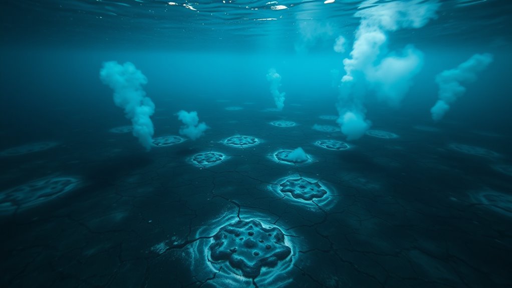
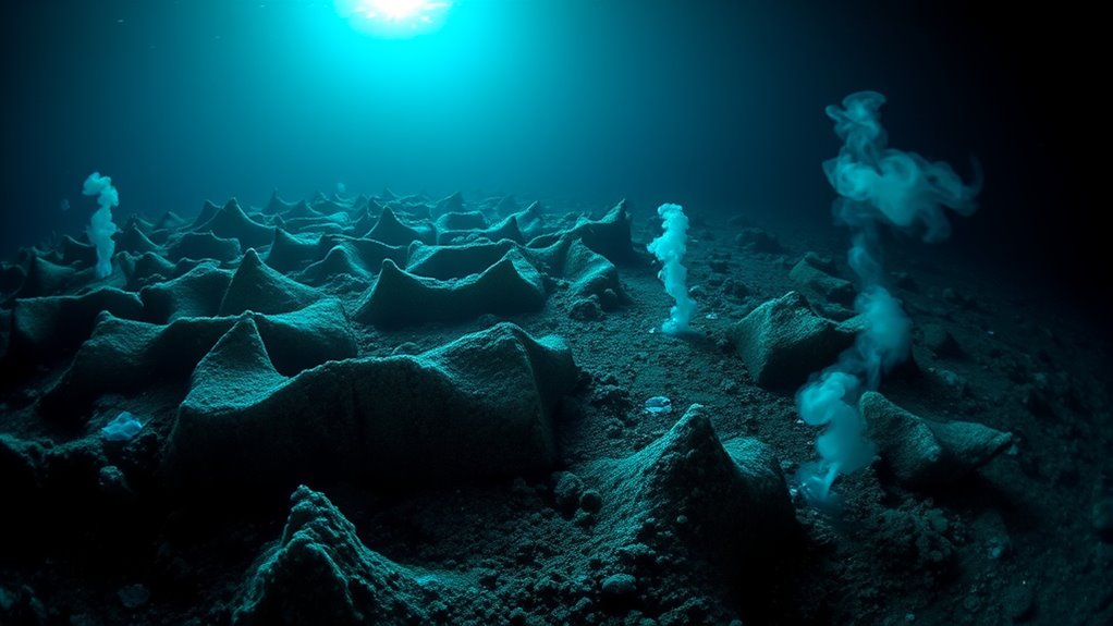
Have you ever wondered what dangers lurk beneath the ocean’s surface? Beneath the waves, a hidden threat exists that many people overlook—methane hydrate deposits trapped within the seafloor. These icy compounds, formed from methane gas and water, are stable under specific pressure and temperature conditions. But as climate change accelerates and ocean temperatures fluctuate, the stability of these deposits comes into question. When methane hydrate destabilizes, it can release vast amounts of methane gas into the water column, potentially triggering underwater landslides or even tsunamis. This makes understanding the distribution and stability of these deposits essential for evaluating risks in areas like the Bermuda Triangle, where mysterious phenomena and natural hazards often intertwine.
Beneath the ocean surface, methane hydrate deposits pose hidden risks of landslides and tsunamis, especially in mysterious areas like the Bermuda Triangle.
The key to predicting potential dangers lies in mapping the seafloor’s stability. Scientists use advanced sonar technology, remotely operated vehicles, and seismic surveys to locate and analyze methane hydrate deposits. These tools help identify zones where hydrate stability is vulnerable, such as areas with changing pressure conditions or warming currents. By studying these zones, you can get a clearer picture of how much methane is stored and how likely it is to be released. You might think of the seafloor as a delicate balance; when disturbed, the entire ecosystem and even human activities on the surface could be impacted. For instance, if a large methane release occurs, it could contribute to greenhouse gas buildup in the atmosphere, further fueling climate change.
Mapping efforts also take into account seafloor features that influence stability, such as faults, slopes, and sediment composition. Steep slopes and fault lines are more prone to destabilization if methane hydrate layers weaken. As temperature increases or pressure decreases, these deposits can start to break apart, creating unstable patches on the seafloor. This process is often slow, but it’s essential to monitor these areas continuously to detect early signs of destabilization. The challenge lies in the vastness of the ocean floor and the difficulty of accessing these deep regions. Nonetheless, ongoing research and exploration are crucial for understanding the potential scale of methane release and for developing mitigation strategies.
In essence, mapping dangerous seafloor methane deposits isn’t just about locating gas pockets; it’s about safeguarding entire ecosystems and human communities. By keeping a close eye on seafloor stability, scientists aim to anticipate and prevent catastrophic events that could arise from methane hydrate destabilization. Understanding the distribution and stability of these deposits helps improve risk assessment and mitigation efforts. As you explore this mysterious world beneath the waves, remember that the more you understand about these hidden dangers, the better prepared you’ll be to face the uncertainties lurking beneath the Bermuda Triangle’s enigmatic waters.
Frequently Asked Questions
What Triggers Methane Releases Beneath the Bermuda Triangle?
You might wonder what triggers methane releases beneath the Bermuda Triangle. Tectonic activity plays a key role, causing shifts in the seafloor that destabilize gas hydrates. When pressure drops or temperatures rise, these hydrates break down, releasing methane gas into the water. This process, known as gas hydrate destabilization, can be sudden and intense, especially in tectonically active regions, leading to the release of dangerous methane plumes into the ocean.
How Do Methane Seeps Affect Local Marine Ecosystems?
Think of methane seeps as hidden treasure chests revealing nature’s secrets. When these seeps occur, they boost local marine ecosystems by supporting deep sea biodiversity, providing habitats for unique species. They also enhance nutrient cycling, fueling the food chain from tiny microorganisms to larger creatures. Your actions can influence these delicate balances, ensuring that these ecosystems thrive and remain resilient amid environmental changes.
Can Methane Explosions Cause Tsunamis or Large Waves?
You might wonder if methane explosions can cause tsunamis or large waves. While sudden methane hydrate destabilization can trigger local seafloor sediment dynamics, it’s unlikely to generate massive waves or tsunamis. The stability of methane hydrate depends on pressure and temperature, and even if destabilized, these events usually cause localized disturbances. Large-scale waves require tectonic shifts, not just methane release, so the risk remains minimal.
Are There Ongoing Efforts to Monitor Methane Emissions Globally?
Imagine you’re watching a weather radar tracking storms — that’s what remote sensors and satellite monitoring do for methane emissions. Yes, ongoing efforts exist worldwide to track these gases, using advanced technology to detect leaks and estimate quantities. These methods help scientists understand potential risks, like sudden releases. By continuously monitoring, we can better predict and prevent environmental hazards linked to methane, ensuring safer oceans and atmospheres.
How Does Seafloor Methane Relate to Climate Change?
You should know that seafloor methane, especially methane hydrate, plays a significant role in climate change. When these hydrates break down, they release methane, a potent greenhouse gas, into the atmosphere. This increase in greenhouse gases traps more heat, intensifying global warming. Scientists are actively studying these processes to better understand their impact on climate change and to develop strategies to mitigate potential future releases of methane into the environment.
Conclusion
So, next time you hear about the Bermuda Triangle, remember there’s a hidden, monstrous threat lurking beneath—massive amounts of seafloor methane. This isn’t just some boring science fact; it’s a potential underwater beast waiting to *release* chaos on the surface. You might think you’re safe, but who knows when these giant methane plumes will explode into the sky, turning calm seas into a catastrophe. Stay curious—and maybe stay away from mysterious triangles in the ocean!