Satellite technology has uncovered many of the Silk Road’s lost cities and trade routes that were hidden under vegetation, sands, or modern development. High-resolution imagery helps you spot ancient roads, city layouts, and surface features invisible to the naked eye. By analyzing patterns and landscape shapes, you can see how these sites connected for centuries of commerce. If you keep exploring, you’ll discover how these discoveries reshape our understanding of ancient trade networks.

Prime made for students and young adults
- Fast, free delivery for dorm and study essentials
- Prime Video and Amazon Music included
- Member-only deals
Key Takeaways
- Satellite imagery uncovers hidden ancient city layouts along the Silk Road, revealing long-lost urban centers.
- Pattern recognition identifies trade route remnants and city connections previously invisible to archaeologists.
- High-resolution scans detect surface features indicating buried or eroded Silk Road sites.
- Comparative imaging over years aids in monitoring preservation and potential threats to these ancient sites.
- Satellite technology transforms understanding of Silk Road trade networks and rediscoveries of vanished cities.
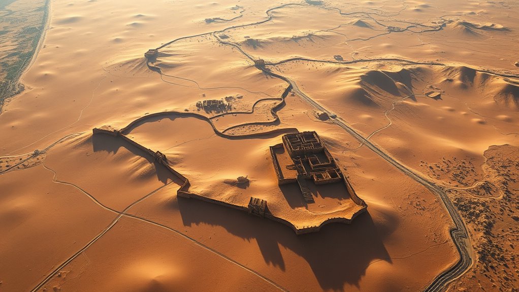
Thanks to advances in satellite technology, archaeologists are now uncovering the hidden remnants of the Silk Road’s lost cities that have long vanished into history. Using satellite archaeology, researchers can scan vast, remote regions where ancient trade routes once thrived. This technological leap allows you to identify subtle surface features—such as mounds, roads, and building foundations—that aren’t visible to the naked eye. As you follow the clues revealed from space, it becomes clear how these sites once played an essential role in facilitating trade, cultural exchange, and economic expansion across Asia, the Middle East, and Europe. High-resolution imagery enhances the ability to detect even the smallest anomalies, making it easier to locate potential archaeological sites before excavation. Satellite imagery provides a bird’s-eye view of landscapes, enabling you to analyze large areas quickly and efficiently. Instead of excavating blindly, archaeologists now target promising sites based on patterns detected from space. For example, linear features may indicate old roads or walls, while circular or rectangular shapes could suggest ancient city layouts or marketplaces. This method is especially effective in regions where dense vegetation, desert sands, or modern development obscure the ancient footprints beneath. As you explore satellite archaeology, you realize how these images help you reconstruct trade routes and understand the spatial organization of these lost civilizations. The rediscovery of Silk Road cities through satellite imagery not only sheds light on ancient trade but also helps you piece together the broader network that connected diverse cultures. You learn that these cities served as hubs where merchants exchanged goods like silk, spices, precious metals, and textiles. By mapping their locations, you see how they were strategically positioned along key routes, facilitating commerce for centuries. This new perspective transforms the way you view historical trade—no longer just a matter of isolated exchanges but a complex web woven into the fabric of Eurasian history. Furthermore, satellite archaeology allows you to monitor changes over time. By comparing images from different years, you can track how these sites have been impacted by natural or human activity. This insight is crucial for preservation efforts and for understanding the long-term sustainability of these ancient trade centers. As you explore these technological advances, it becomes evident that satellite imagery is revolutionizing archaeology, offering a non-invasive, cost-effective way to uncover stories buried beneath the surface. In addition, the use of advanced imaging techniques enables you to analyze subsurface features without disturbing the sites, further enhancing preservation efforts. In essence, satellite technology empowers you to see beyond what’s immediately visible, revealing the silent testimony of the Silk Road’s once-bustling cities. This approach opens new pathways for discovery, making the ancient trade routes more tangible than ever before, and helping you appreciate how interconnected the world once was through these vibrant centers of commerce and culture.
satellite imagery analysis tools
As an affiliate, we earn on qualifying purchases.
As an affiliate, we earn on qualifying purchases.
Frequently Asked Questions
How Accurate Are Satellite Images in Identifying Ancient City Ruins?
Satellite images can be quite accurate in identifying ancient city ruins, especially when combined with ground truth data. High image resolution helps you see detailed features, making it easier to distinguish ruins from natural formations. However, the accuracy depends on factors like image quality and the terrain. Ground truth verification is essential to confirm findings, ensuring you don’t mistake natural features for archaeological remains.
What Technologies Are Used Alongside Satellites for Archaeological Discoveries?
You use a range of technologies alongside satellites for archaeological discoveries. Ground penetrating radar helps you detect underground structures without excavation, while drone surveillance offers detailed aerial views of sites, capturing high-resolution images and mapping terrain. These tools complement satellite imagery, allowing you to pinpoint potential ruins, analyze site features, and plan excavations more efficiently, making your exploration more precise and less invasive.
Are There Any Political or Environmental Challenges in Exploring These Sites?
You might face political and environmental challenges when exploring archaeological sites. Legal restrictions can limit access, especially if sites are protected or in disputed regions. Cultural sensitivities also matter, as local communities may oppose excavation efforts to preserve their heritage. Environmental factors like climate change or fragile ecosystems can further complicate exploration. Managing these issues requires respectful collaboration with local authorities and communities to guarantee responsible discovery and preservation.
How Do Satellite Findings Influence Current Understanding of Silk Road History?
You might think satellite findings only reveal ancient sites, but they actually reshape your understanding of trade routes and cultural exchanges. These discoveries confirm long-held theories about the Silk Road’s extent and significance, showing how interconnected ancient civilizations truly were. By uncovering hidden cities, satellites help you see the Silk Road as more than just a route — it’s a vibrant network that fueled cultural exchanges and shaped history in ways previously unimagined.
Can Satellite Data Help Protect These Ancient Sites From Modern Threats?
Satellite data can definitely help you protect these ancient sites from modern threats like climate change and illegal excavations. By monitoring changes over time, you can spot early signs of erosion, flooding, or unauthorized activities. This technology allows you to prioritize preservation efforts, alert authorities quickly, and develop strategies to mitigate damage, ensuring these historic locations are preserved for future generations.
archaeology drone with high-resolution camera
As an affiliate, we earn on qualifying purchases.
As an affiliate, we earn on qualifying purchases.
Conclusion
You see the Silk Road’s lost cities come alive once more, their stories unfolding through satellite eyes. You witness history reborn, mysteries unraveled, and connections rekindled. You feel the thrill of discovery, the weight of the past, and the promise of knowledge. You’re part of this journey, bridging centuries, revealing secrets, and igniting curiosity. Because in rediscovering these lost cities, you’re not just observing history—you’re shaping its future.
remote sensing equipment for archaeology
As an affiliate, we earn on qualifying purchases.
As an affiliate, we earn on qualifying purchases.
satellite image processing software
As an affiliate, we earn on qualifying purchases.
As an affiliate, we earn on qualifying purchases.
Fall Picks
fall essentials
As an affiliate, we earn on qualifying purchases.