
Using modern technology like satellite imaging and drones, you can quickly scan large areas to locate hidden ancient cities. These tools detect surface anomalies, soil differences, and vegetation changes caused by buried structures. Spectral data helps confirm human activity, while high-resolution aerial photos reveal subtle ground features. Together, these advances make the search faster, more precise, and exciting. Keep exploring to discover how these innovations are uncovering long-lost civilizations once thought unreachable.
Key Takeaways
- Satellite imaging detects surface anomalies and vegetation differences indicating buried structures or ancient city layouts.
- Spectral data analysis reveals soil and vegetation variations caused by past human activity.
- Drone technology provides high-resolution images of inaccessible terrain, uncovering subtle ground features.
- Integrating satellite, topographical, and cartographic data creates detailed visualizations for targeted excavations.
- Modern tools accelerate discovery, improve accuracy, and reveal hidden ancient civilizations previously undetectable.

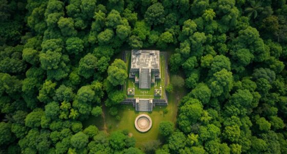
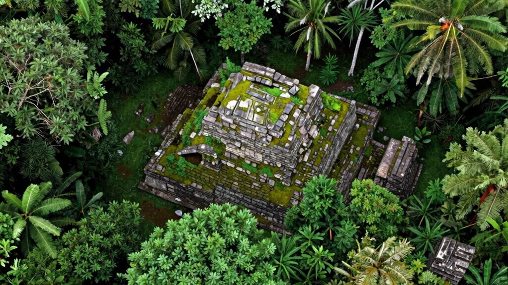
Ancient lost cities, long hidden beneath layers of earth and jungle, are now being uncovered thanks to cutting-edge technology. You might think these sites are lost forever, but advances in ancient mapping and satellite imaging have transformed how archaeologists locate these hidden treasures. You can see that satellite imaging allows you to scan vast regions quickly, revealing subtle surface anomalies that point to buried structures or roads. These images can highlight differences in vegetation or soil composition caused by underlying ruins, giving you clues about where to focus your excavation efforts.
With ancient cartography techniques, you can create detailed models of landscapes and understand how ancient cities were laid out. By combining satellite images with topographical data, you gain a clearer picture of what might be beneath the surface. These maps help you visualize the relationships between different structures, such as temples, plazas, and residential areas, even if they’re not immediately visible. This synergy of technology lets you plan more precise digs, reducing unnecessary disturbance to the environment. It’s like having a detailed blueprint of a city long gone, guiding you directly to its core.
Ancient cartography combines satellite and topographical data to reveal hidden city layouts and guide precise excavations.
The real power of modern technology lies in its ability to reveal what the naked eye cannot see. Satellite imaging captures spectral data across multiple wavelengths, which can detect differences in soil and vegetation that indicate human activity. For example, you might notice areas where crops grow differently or where patches of soil are more disturbed—signs that ancient buildings or pathways lie beneath. These insights allow you to prioritize excavation sites with greater confidence, increasing the efficiency and success rate of uncovering lost civilizations.
In addition, drone technology complements satellite imaging by providing high-resolution aerial photographs. You can fly over difficult terrain and get detailed images that highlight subtle features on the ground. This layered approach—combining satellite data, ancient mapping, and drone imagery—gives you a comprehensive toolkit for exploring the past. As you piece together these clues, the once-mysterious outlines of lost cities begin to emerge, revealing stories long buried beneath centuries of jungle or earth. Thanks to modern technology, the process of discovery is faster, more accurate, and more exciting than ever before, opening a window into ancient worlds that were nearly impossible to find just a few decades ago.
FPV GPS Module with QMC5883L Compass, Upgraded Dual Protocol 10th Chip Drone GPS,Fast Satellite Positioning for RC FPV Drone Racing Fixed-Wing
Upgraded 10th Generation Chip: Adopting the new 10th generation chip, with high sensitivity, low power consumption, miniaturization
As an affiliate, we earn on qualifying purchases.
As an affiliate, we earn on qualifying purchases.
Frequently Asked Questions
What Are the Earliest Examples of Lost City Discoveries?
The earliest examples of lost city discoveries include the rediscovery of Machu Picchu in 1911 and the ancient city of Troy in the 19th century. Today, you can explore these sites using satellite imagery and drone surveys, which help locate and map hidden ruins from above. These modern tools make it easier to find lost cities, revealing secrets buried beneath the surface and expanding our understanding of ancient civilizations.
How Do Archaeologists Differentiate Between Natural Features and Ruins?
You differentiate between natural features and ruins using satellite imagery and ground penetrating radar, much like spotting a hidden trail amid familiar woods. Satellite images reveal unusual shapes or alignments, hinting at man-made structures, while ground penetrating radar uncovers buried walls or artifacts without excavation. By comparing these data, you can tell whether you’re looking at a natural formation or ancient ruins, guiding your exploration with precision.
What Role Do Local Legends Play in Locating Lost Cities?
You can find lost cities by paying attention to folklore myths and cultural stories passed down through generations. These legends often contain clues or descriptions that point archaeologists toward potential locations. By analyzing these stories critically, you might identify patterns or landmarks linked to real sites. Combining local legends with modern technology, like satellite imaging, increases your chances of uncovering hidden ruins that have long been buried beneath the earth.
How Accurate Are Modern Dating Techniques in Confirming Discoveries?
Modern dating techniques act like precise compass needles, guiding you through the past. Radiocarbon calibration refines age estimates, making them highly accurate, while DNA analysis confirms origins and connections. Together, they guarantee discoveries are solid and trustworthy, like a well-mapped treasure. Although no method is flawless, these techniques provide a reliable timeline, helping you confidently piece together history’s puzzle with scientific certainty.
What Challenges Do Researchers Face When Exploring Deep Underground Sites?
When exploring deep underground sites, you face challenges like limited access and complex geology. Using geophysical surveys helps you identify promising areas, but underground mapping remains tricky due to variable terrain and depth. You must interpret data carefully to avoid false positives. Additionally, you deal with physical obstacles, safety concerns, and the need for precise technology to prevent damaging fragile remains, making your work both demanding and rewarding.

MSMV High-Resolution 4K HD Camera Drone, Wireless RC Toys for Boys Girls, One Button Return, Emergency Stop, Headless Mode, 360° Flips, 2 Batteries & Carrying Case for Kids Adults Beginners, Black
This MSMV drone with camera is fitted with high-resolution 4K HD camera. As practical 4K drones with camera…
As an affiliate, we earn on qualifying purchases.
As an affiliate, we earn on qualifying purchases.
Conclusion
With modern technology, you’re now wielding tools so powerful they can reveal secrets buried for centuries, as if you hold the keys to the lost world itself. Every satellite image, sonar scan, and drone flight brings entire civilizations to light, transforming ancient mysteries into clear, tangible history. It’s almost as if time itself bends to your will, revealing the hidden stories of lost cities with breathtaking precision and making the impossible seem just within reach.

Novel Applications of Optical Sensors and Machine Learning in Agricultural Monitoring
As an affiliate, we earn on qualifying purchases.
As an affiliate, we earn on qualifying purchases.

Humminbird Autochart DVD PC Mapping Software w/Zero Lines Map Card
Zero Lines Map Card: The starting point to your mapping adventure.
As an affiliate, we earn on qualifying purchases.
As an affiliate, we earn on qualifying purchases.