
Volcanoes are hard to predict because they are complex systems influenced by many hidden underground processes that we can’t directly observe. Warning signs like earthquakes, gas emissions, and ground deformation can be subtle, ambiguous, or inconsistent, making interpretation difficult. Monitoring remote or dangerous areas adds to the challenge, and models often rely on incomplete information. If you want to understand more about what makes volcanoes so unpredictable, keep exploring the details behind these natural phenomena.
Key Takeaways
- Volcanoes have unique structures, magma compositions, and histories, requiring site-specific understanding for accurate prediction.
- Warning signals like earthquakes and gas emissions are inconsistent, subtle, or ambiguous, often failing to reliably indicate eruptions.
- Underground magma movement and pressure buildup are difficult to observe directly, limiting comprehensive monitoring.
- Many volcanoes are located in remote or hazardous areas, complicating continuous observation and data collection.
- Current models lack complete understanding of underground processes, leading to guesses rather than definitive forecasts.
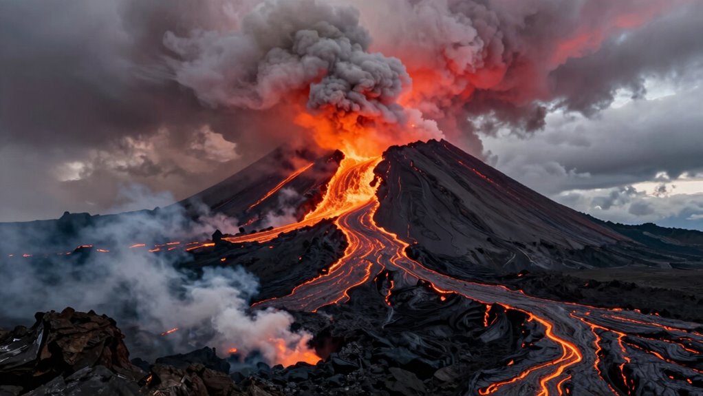
Have you ever wondered why predicting volcanic eruptions remains so challenging? The answer lies in the intricate geological complexity and the unpredictable nature of warning signals. Volcanoes are dynamic systems shaped by countless factors that interact in ways scientists are still working to fully understand. Unlike weather forecasts, which rely on well-established models, volcanic activity depends on a web of variables that can change rapidly and unexpectedly. This geological complexity makes it difficult to establish clear, reliable indicators that a major eruption is imminent. Every volcano has its own unique structure, magma composition, and history, which means a one-size-fits-all approach just doesn’t work. You need detailed, site-specific knowledge, and even then, surprises are common.
Predicting eruptions is difficult due to unique volcano structures and unpredictable warning signals.
Warning signal variability adds another layer of difficulty. Earthquakes, ground deformation, gas emissions, and thermal changes often serve as the first clues of unrest. But these signals don’t always lead to eruption, and when they do, the timing and severity can vary widely. Sometimes, seismic activity ramps up days or weeks before an eruption, giving some warning, but at other times, the volcano erupts with little or no detectable warning. This inconsistency hampers prediction efforts, leaving scientists in a constant race to interpret signals correctly. It’s like trying to read a complex, ever-changing code that can shift unexpectedly. You might see signs pointing toward an eruption, but they aren’t foolproof, and false alarms are a real concern.
Adding to the challenge is the fact that many volcanoes are located in remote or hazardous areas, making continuous monitoring difficult. Despite advances in technology, some volcanoes remain poorly understood because there’s limited data. Even with sophisticated sensors and satellite imagery, capturing the full picture of underground magma movement and pressure buildup remains elusive. The underground processes are hidden from view, and their signals can be subtle or ambiguous. Because of this, scientists often have to make educated guesses based on incomplete information, which increases uncertainty. the unpredictable nature of warning signals can further hinder accurate forecasts, as these signals may not always follow predictable patterns. Moreover, the geological complexity of each volcano means that models must be tailored to individual systems, making universal solutions impractical. This variability in volcanic behavior underscores how much remains unknown about these powerful natural systems. Recognizing these limitations highlights the importance of ongoing research and technological innovation in the field of volcanology.

3D Printer T-K500 m3 x 15mm K Type Thermocouple Sensor K-Type Compatible with Volcano V6 HOTEND Block 500℃ PEI PEEK High Temperature 3D Printing
This Thermocouple sensor is 3mm x 15mm cylindrical package with 1 meter long cable compatibility with all ID…
As an affiliate, we earn on qualifying purchases.
As an affiliate, we earn on qualifying purchases.
Frequently Asked Questions
How Do Scientists Monitor Underground Magma Movement?
You can monitor underground magma movement by tracking seismic activity and ground deformation. Seismic sensors detect tiny tremors caused by magma shifting beneath the surface, alerting scientists to potential eruptions. Ground deformation measurements reveal changes in the volcano’s shape, indicating magma rising or moving. Combining these data sources helps scientists assess eruption risks, but unpredictable factors still make volcano forecasting challenging.
Can Animal Behavior Predict Volcanic Eruptions?
Animal behavior can sometimes hint at volcanic eruptions because their instincts and behavior patterns change before eruptions occur. You might notice animals becoming restless, fleeing, or acting strangely because they sense subtle environmental shifts humans can’t detect. While these signs aren’t foolproof, observing unusual animal behavior can serve as an early warning, helping you stay alert to possible volcanic activity, especially in regions with frequent eruptions.
What Role Do Gas Emissions Play in Prediction?
Gas emissions act like a volcano’s heartbeat, revealing hidden stress beneath the surface. You monitor gas composition and eruption indicators to understand when a volcano might erupt. Changes in gas levels, such as increased sulfur dioxide, signal rising magma and alert you to potential danger. By paying close attention to these signs, you gain essential clues, making it possible to anticipate eruptions more accurately and protect communities from sudden bursts of fury.
Are There Any Recent Advances in Eruption Forecasting?
Recent advances in eruption forecasting include improved monitoring techniques like seismic sensors, satellite imagery, and gas analysis. These tools help detect subtle signs like changes in volcanic rock stress or early lava flows. You can now get more accurate alerts, enabling timely evacuations. While predicting precise eruptions remains complex, these innovations markedly enhance preparedness, especially by tracking volcanic rock movements and lava flow patterns, reducing risks for communities near active volcanoes.
How Does Volcanic Ash Dispersal Affect Prediction Accuracy?
Ash dispersal considerably affects prediction accuracy because wind influence varies constantly, making it difficult to forecast where ash will fall. You must consider wind speed and direction at different altitudes, which can change rapidly. These unpredictable atmospheric conditions cause ash clouds to spread unevenly, complicating evacuation plans and aviation safety. As a result, scientists face challenges in creating precise ash dispersal models, impacting overall eruption prediction reliability.
National Geographic Ultimate Volcano Kit – Erupting Volcano Science Kit for Kids, 3X More Eruptions, Pop Crystals Create Exciting Sounds, STEM Science & Educational Toys (Amazon Exclusive)
MORE ERUPTIONS EQUALS MORE FUN – This kids science kit packs more eruption powder than ever before! You…
As an affiliate, we earn on qualifying purchases.
As an affiliate, we earn on qualifying purchases.
Conclusion
Predicting volcanoes remains a challenge because they act unpredictably, with eruptions sometimes occurring without clear warning signs. Despite advances, scientists still struggle to forecast nearly 50% of eruptions accurately. This unpredictability means communities near volcanoes must stay alert and prepared, even when no signs seem apparent. Understanding these natural giants better is essential for safety, but their complex behavior keeps us on our toes, reminding you that nature’s power is both awe-inspiring and unpredictable.

CertBuy 2 Pack Rock Pick Hammer With Non-Skid Handle, 12.8 Inch All Steel Geologist Hammer, Drop Forged Masonry Hammers, Geologist Hammers with Pointed Tip for Mining
High Quality Rock Pick: This all-steel drop-forged rock pick hammer is heat treated and tempered for high strength…
As an affiliate, we earn on qualifying purchases.
As an affiliate, we earn on qualifying purchases.

HAZARD 4 Beacon Light Kit-B – LED Core – Rechargeable Wireless Strobe Device – Amber Warning Light – Battery Powered – Includes Boot Cover, SG1, Screws/Plugs, Nuts/Plugs, Charge Cable
RECHARGEABLE WIRELESS STROBE LIGHT – The HAZARD 4 Beacon Light Kit-B features a rechargeable LED beacon ideal for…
As an affiliate, we earn on qualifying purchases.
As an affiliate, we earn on qualifying purchases.